![](/images/other/stat-length.png)
![Trail Walking Le Thoronet - le thoronet_pont d'argent_canal ste croix - Photo](https://media.geolcdn.com/t/1900/400/2e5e538d-a657-4ba7-8869-d7ca6ae35c0f.jpg&format=pjpeg&maxdim=2)
le thoronet_pont d'argent_canal ste croix
bernir
User
![Length](/images/other/stat-length.png)
![Max alt](https://static1.geolcdn.com/siteimages/upload/files/1508320355ic_sort_altitude_max_24dp.png)
![Uphill gradient](https://static1.geolcdn.com/siteimages/upload/files/1508320355ic_sort_den_pos_24dp.png)
![Km-Effort](/images/other/stat-length.png)
![Min alt](https://static1.geolcdn.com/siteimages/upload/files/1508320355ic_sort_altitude_min_24dp.png)
![Downhill gradient](https://static1.geolcdn.com/siteimages/upload/files/1508320355ic_sort_den_neg_24dp.png)
![Boucle](https://static1.geolcdn.com/siteimages/upload/files/16400158638029165_repeat_loop_refresh_sync_direction_icon.png)
![Walking](https://static1.geolcdn.com/sitytour/trail-icons/101.png)
5h03
Difficulty : Very easy
![Scan this QR Code to open this trail in the SityTrail application](https://capi.geolives.com/qq0zvz2zws4bq2lad0pu/sitytour/trails/2720673/qr.png?size=200)
FREE GPS app for hiking
About
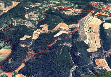
Trail Walking of 9.9 km to be discovered at Provence-Alpes-Côte d'Azur, Var, Le Thoronet. This trail is proposed by bernir.
Description
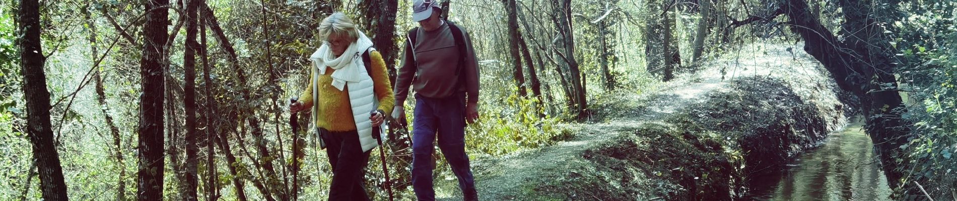
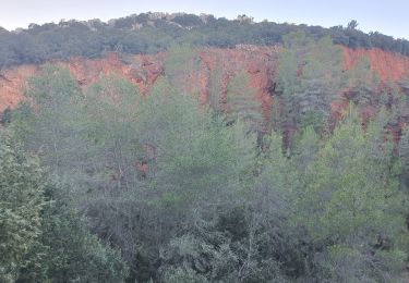
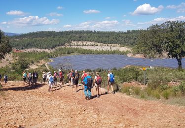
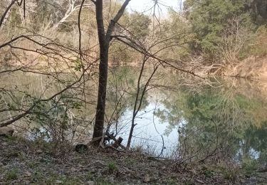
quelle belle journée ! ,c'est une équipe de 13 à la bonne humeur intacte malgré les dérobades du point de départ , qui chemine sur le talus bordant le canal de sainte croix .un sentier étroit et rendu parfois périlleux par le labour des sangliers , il fallait éviter la glissade dans l'eau d'un côté ou dévaler sur la route de l'autre ! des petits ponts de pierre , du soleil jouant à travers le sous bois , des fleurettes éparses ,violettes , monnaie du pape , bourraches ,orties et un semis de coquillages qui sembleraient être des "palourdes asiatiques ou corbicules "proliférant en eaux douces .Puis , la découverte de l'Argens, des cascades, un beau plan d'eau reflétant la végétation et miroitant sous le soleil, le tout se prêtant avec complaisance au mitraillage des smartphones, le coin rêvé pour la pause repas !!
mais il fallut quitter ce coin idyllique pour revenir par des sentiers en lisière de belles étendues de vignes ,bien encadrées au loin par les collines , leurs ceps tortueux bien taillés pour attendre sagement l'éclatement des bourgeons .Quelques belles maisons , belles propriétés aux arbres en fleurs puis le Pont d'Argens pour la traditionnelle photo de groupe .
une rando rafraichissante ,des paysages si différents des rochers et chemins pierreux de nos sorties habituelles , un autre aspect de notre belle région .
...
Annie le26 03 2021
Positioning
Comments
Trails nearby
![Trail Walking Le Thoronet - SityTrail - Abbayie de Torronet - Photo](https://media.geolcdn.com/t/375/260/c1345155-8a53-4785-b8e1-556f37370f25.jpg&format=jpg&maxdim=2)
![Walking Walking](https://static1.geolcdn.com/sitytour/trail-icons/101.png)
Walking
![](/images/other/stat-length.png)
![](https://static1.geolcdn.com/siteimages/upload/files/16400158638029165_repeat_loop_refresh_sync_direction_icon.png)
![Trail Walking Le Thoronet - 2023-01-12 Le Thoronet- Chemin des moines - Photo](https://media.geolcdn.com/t/375/260/a61d5b67-2b87-4718-8049-a50916c47930.jpg&format=jpg&maxdim=2)
![Walking Walking](https://static1.geolcdn.com/sitytour/trail-icons/101.png)
Walking
![](/images/other/stat-length.png)
![](https://static1.geolcdn.com/siteimages/upload/files/16400158638029165_repeat_loop_refresh_sync_direction_icon.png)
![Trail Walking Le Thoronet - Trace_Thoronet - Photo](https://media.geolcdn.com/t/375/260/8ba50d89-4322-43c3-92b6-dad72fbe2d40.jpg&format=jpg&maxdim=2)
![Walking Walking](https://static1.geolcdn.com/sitytour/trail-icons/101.png)
Walking
![](/images/other/stat-length.png)
![](https://static1.geolcdn.com/siteimages/upload/files/16400158638029165_repeat_loop_refresh_sync_direction_icon.png)
![Trail Walking Lorgues - Lorgues et l'Ermitage Saint-Ferréol - Photo](https://media.geolcdn.com/t/375/260/e62c5b83-8a2e-4772-82d8-7fdc4c20c935.jpg&format=jpg&maxdim=2)
![Walking Walking](https://static1.geolcdn.com/sitytour/trail-icons/101.png)
Walking
![](/images/other/stat-length.png)
![](https://static1.geolcdn.com/siteimages/upload/files/16400158638029165_repeat_loop_refresh_sync_direction_icon.png)
![Trail Walking Le Thoronet - Abbayie de Torronet - Photo](https://media.geolcdn.com/t/375/260/8fc4cfe5-b20b-4ac4-95db-dfa07c3edf80.jpg&format=jpg&maxdim=2)
![Walking Walking](https://static1.geolcdn.com/sitytour/trail-icons/101.png)
Walking
![](/images/other/stat-length.png)
![](https://static1.geolcdn.com/siteimages/upload/files/16400158638029165_repeat_loop_refresh_sync_direction_icon.png)
![Walking Walking](https://static1.geolcdn.com/sitytour/trail-icons/101.png)
Walking
![](/images/other/stat-length.png)
![](https://static1.geolcdn.com/siteimages/upload/files/16400158638029165_repeat_loop_refresh_sync_direction_icon.png)
![Trail Nordic walking Le Thoronet - Le Thoronet - La vigie des Ubacs - Photo](https://media.geolcdn.com/t/375/260/ext.jpg?maxdim=2&url=https%3A%2F%2Fservices.sitytrail.com%2FGeolivesWS%2FDownloadMedia.ashx%3FTrailID%3D512603%26Media%3Dfix__20160112162511.jpg)
![Nordic walking Nordic walking](https://static1.geolcdn.com/sitytour/trail-icons/102.png)
Nordic walking
![](/images/other/stat-length.png)
![](https://static1.geolcdn.com/siteimages/upload/files/16400158638029165_repeat_loop_refresh_sync_direction_icon.png)
![Trail Walking Le Thoronet - Abbaye Thoronet - Lac de Carcès rando - Photo](https://media.geolcdn.com/t/375/260/ext.jpg?maxdim=2&url=https%3A%2F%2Fservices.sitytrail.com%2FGeolivesWS%2FDownloadMedia.ashx%3FTrailID%3D405651%26Media%3Dfix__20150408104649.jpg)
![Walking Walking](https://static1.geolcdn.com/sitytour/trail-icons/101.png)
Walking
![](/images/other/stat-length.png)
![](https://static1.geolcdn.com/siteimages/upload/files/16400158638029165_repeat_loop_refresh_sync_direction_icon.png)
![Trail Walking Le Thoronet - Thoronet Canal de Sainte-Croix - Photo](https://media.geolcdn.com/t/375/260/52be4161-0611-41dd-b691-680f0740539e.jpg&format=jpg&maxdim=2)
![Walking Walking](https://static1.geolcdn.com/sitytour/trail-icons/101.png)
Walking
![](/images/other/stat-length.png)
![](https://static1.geolcdn.com/siteimages/upload/files/16400158638029165_repeat_loop_refresh_sync_direction_icon.png)